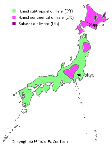
The most of Japan belong to temperate regions. In the southern archipelago, subtropical climate, the north become the climate of the subarctic zone. It is oceanic climate, but I am affected by the monsoon of autumn from summer, and it becomes cold, and it snows by the periodic wind from the continent basically in winter. It is a Japanese meteorological characteristic the difference of the heat and cold of the four seasons is big, and to have much precipitation. Japan is a small country, but temperature is big by a place by the same time and, for a country (and I do it in about 3,000km, the latitude, about 20 degrees) that is slim in the north and south, is different. A large quantity of snow falls so that the Siberia high atmospheric pressure of the continent becomes superior, and northwest periodic wind blows in the winter season, and a large quantity of steam evaporates from Tsushima Current of the warm current in the Sea of Japan which is the way. Therefore about 52% of the country are heavy snowfall areas around Sea of Japan side, and it is a heavy snowfall area eminent in the world. On the contrary, a lot of days of the fine weather that air dried follow in the Pacific side. The influence of the Pacific high is strong, and, as for the summer, the day of the high temperature high humidity continues. I am called "Tuyu (梅雨, the rainy season)" in Japan in July from June, and a rainy day continues any place other than Hokkaido. In addition, a typhoon strikes Japan in October from August, and rain increases via the sea near the shore. But there can be the thing that the influence of the Sea of Okhotsk high atmospheric pressure strongly becomes the low temperature around Hokkaido northern part. Even if Japan looks worldwide, it is a comparatively area with much precipitation. It is the typhoon that a front is delayed to (Okinawa / Amami-shoto Islands, May and June) as for the main reason in snowfall of the winter season in the Sea of Japan side, June and July, and it can write it in a fall from the summer in the rainy season to have it, and an approach strikes from the south sea. The Japanese annual precipitation is about 1,700mm.
In a season for Japan Travel, it is with in spring (April and May) or autumn (October and November). The day when temperature is easy to spend the humidity at around 20 degrees low by the time when the fine weather is calm continues. A cherry tree blooms in all over Japan in spring, and autumn colors are clean in autumn. In addition, Hokkaido of the winter is attractive, too. It is very cold, but the world of the silver spreads out and can watch beautiful scenery in severe nature.
Highest recorded temperatur: 40.9 °C (on August 16, 2007, at Kumagaya,Saitama and Tajimi, Gifu)
Lowest recorded temperature: -41.0 °C (on January 25, 1902, at Asahikawa, Hokkaido)
Maximum rainfall par hour: 153 mm (on October 27, 1999, at Katori, Chiba)
Maximum rainfall par day: 844 mm (on August 1, 1982, at Mt.Hinode-ga-dake, Nara)
Highest Wind speed: 72.5m/s (on April 5, 1942, at Mt.Fuji-san)
When the city name is clicked, it moves to the page with the temperature and the precipitation graph.
And, the map and the weather forecast are included in major city of Japan.
In the place with the icon next to the city name, there is a graph where it can know the influence by the global warming such as "Mean maximum temperature and lowest temperature graph", "Detailed graph of the average height temperature change", "It is a snowfall during year", and "Annual rainfall" of 50-100 years.
 The most of Japan belong to temperate regions. In the southern archipelago, subtropical climate, the north become the climate of the subarctic zone. It is oceanic climate, but I am affected by the monsoon of autumn from summer, and it becomes cold, and it snows by the periodic wind from the continent basically in winter. It is a Japanese meteorological characteristic the difference of the heat and cold of the four seasons is big, and to have much precipitation. Japan is a small country, but temperature is big by a place by the same time and, for a country (and I do it in about 3,000km, the latitude, about 20 degrees) that is slim in the north and south, is different. A large quantity of snow falls so that the Siberia high atmospheric pressure of the continent becomes superior, and northwest periodic wind blows in the winter season, and a large quantity of steam evaporates from Tsushima Current of the warm current in the Sea of Japan which is the way. Therefore about 52% of the country are heavy snowfall areas around Sea of Japan side, and it is a heavy snowfall area eminent in the world. On the contrary, a lot of days of the fine weather that air dried follow in the Pacific side. The influence of the Pacific high is strong, and, as for the summer, the day of the high temperature high humidity continues. I am called "Tuyu (梅雨, the rainy season)" in Japan in July from June, and a rainy day continues any place other than Hokkaido. In addition, a typhoon strikes Japan in October from August, and rain increases via the sea near the shore. But there can be the thing that the influence of the Sea of Okhotsk high atmospheric pressure strongly becomes the low temperature around Hokkaido northern part. Even if Japan looks worldwide, it is a comparatively area with much precipitation. It is the typhoon that a front is delayed to (Okinawa / Amami-shoto Islands, May and June) as for the main reason in snowfall of the winter season in the Sea of Japan side, June and July, and it can write it in a fall from the summer in the rainy season to have it, and an approach strikes from the south sea. The Japanese annual precipitation is about 1,700mm.