旅行のとも、ZenTech >
海外旅行 地図 >
南ヨーロッパ地図 >
アルバニア地図 >
アルバニア世界遺産地図
ブトリント
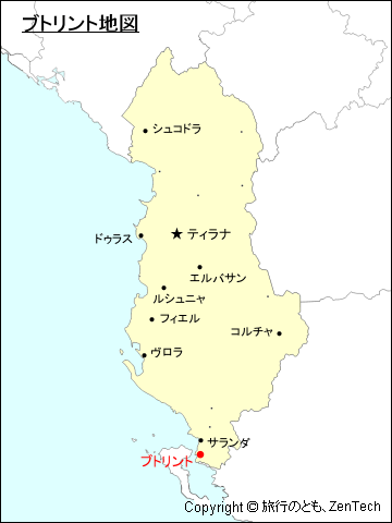
ブトリント(Butrint)は、アルバニア共和国南部にある古代ローマ遺跡で、世界遺産(文化遺産)に登録されています。伝説によれば、街の創設者はトロイ王であったプリアモスの子ヘレヌスとされています。古代ローマの詩人ヴェリギリウスの叙事詩(ローマ建国神話)「アエネーイス」にも登場する歴史ある街で、トロイ陥落後に安住の地を求め地中海世界を放浪したアエネーイスがイタリアへ渡る前にブトリントを訪れたとされています。最寄の大きな街は、サランダ(ブトリント遺跡まで南へ約15km)で路線バス(一日6便、所要時間 1時間)があります。
ヴロラ州サランダ県ブトリント地図(Map of Butrint, Saranda District, Vlore County, Albania)
ブトリントの交通機関と観光名所
- ブトリントの交通機関
- ケーブル・フェリー
- ブトリントの観光名所
- 医学の神「アスクレピウス」の聖域 / A 4th century BC sanctuary dedicated to the healing god, Asdepius:紀元前4世紀
- ローマ円形劇場 / The 3rd-century BC Theater; later adapted to a Roman design with a stage building:紀元前3世紀
- ローマ浴場 / A Roman bath-house of the 2nd century AD:紀元2世紀
- アゴラ・フォルム / The Agora/Forum, the civic and commercial heart of the city:町の中心広場
- ギュムナシオン / The 'gymnasium' probably a pagan sacred site, later converted into a church:古代ギリシアの競技選手の訓練場、後世には教会に転用
- 洗礼堂 / An early 6th-century baptistery with mosaic floor representing Christian salvation:6世紀初期、モザイク画の床があります。
- ローマ時代の住宅 / A Roman town house converted into a Palace with a triconch dining room in the 5th century:紀元5世紀、テトラコンチ型(四つ葉型)建築で後に宮殿に転用
- ニンフの噴水 / A 2nd-century AD fountain, dedicated to the Nymphs by a local woman, junia Rufina:紀元2世紀、ブトリントの女性ジュニア・ルフィナがニンフ(ギリシャ神話の妖精)に捧げた噴水
- 大聖堂(初期キリスト教教会) / The Great Basilica, an early Christian church, constructed in the 6th century AD:6世紀
- レイク・ゲート / The Lake Gate, a fine Hellenistic gate in the 4th century BC walls:紀元前4世紀の城壁に造られた緻密なヘレニズム様式の門
- ライオン・ゲート / The Lion Gate - a further gate rebuilt in the middle ages:現在の門は中世に再建された門
- アクロポリス / The acropolis, Settlement on the hill dates back to the 8th century BC:紀元前8世紀まで歴史を遡ることができます。
- ベネチア時代の城(博物館) / A 14th - 16th cneturies Venetian castle, reconstructed in the 1903s:14世紀から16世紀に建設、現在の城は1930年代に再建
- ベネチア時代の塔 / A Venetian tower constructed in the 15th - 16th cneturies:15世紀から16世紀に造られた塔
- 砦
アルバニアにおけるブトリントの位置が判る地図

地図サイズ:360ピクセル X 480ピクセル
ページ先頭(アルバニア:ブトリント地図)へもどる
 トップページへ移動する。
Copyright © 1997-2026 ZenTech. All Rights Reserved
