Travel Friend, ZenTech > Climate Guide

South Korea Climate

Travel Friend, ZenTech

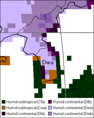
Climate Zones of South Korea
South Korea Climate Map
 
Seoul, Seoul National Capital Area Temperature & Precipitation Monthly Averages, Seoul Temperature Graph
Seoul is capital of South Korea.
MonthJanFebMarAprMayJunJulAugSepOctNovDec
Average High Temperature (°C)1.64.110.217.622.826.928.829.525.619.711.54.2
Average Low Temperature (°C)-6.1-4.11.17.312.617.821.822.116.79.82.9-3.4
Average Precipitation (mm)21.623.645.877102.2133.3327.9348137.649.35324.9
Rainy Days7.166.888.81015.513.88.76.697.3
Seoul Year Average Temperature 12.5 °C, Year Average High Temperature 16.9 °C, Year Average Low Temperature 8.2 °C, The average annual rainfall 1344.2 mm
 
When the city name is clicked, it moves to the page with the temperature and the precipitation graph.
And, the map and the weather forecast are included in major city of South Korea.
AreaProvinceCity
CapitalSeoul National Capital AreaSeoul (Korean : 서울 , Chinese character : 首爾)
NorthIncheon Metropolitan CityIncheon , Ganghwa-do Island
Gangwon ProvinceChuncheon , Gangneung , Sokcho , Wonju
Gyeonggi ProvinceOsan , Suwon
CentralDaejeon Metropolitan CityDaejeon
North Chungcheong ProvinceChungju
North Gyeongsang ProvinceAndong , Gyeongju , Pohang , Ullung Island
South Chungcheong ProvinceBuyeo
SouthBusan Metropolitan CityBusan (Pusan , 부산 , 釜山)
Daegu Metropolitan CityDaegu
Ulsan Metropolitan CityUlsan
Gwangju Metropolitan CityGwangju
Jeju Special Self-Governing ProvinceJeju
North Jeolla ProvinceGunsan , Jeonju , Namwon
South Gyeongsang ProvinceJinju , Masan , Miryang
South Jeolla ProvinceMokpo , Yeosu
External link : Korea Meteorological Administration ( 기상청 )
 
Contents related to in site
 
To the top (South Korea Climate)
Travel Friend, ZenTech - Japanese (Japanese)   Copyright © 1997-2023 ZenTech. All Rights Reserved.