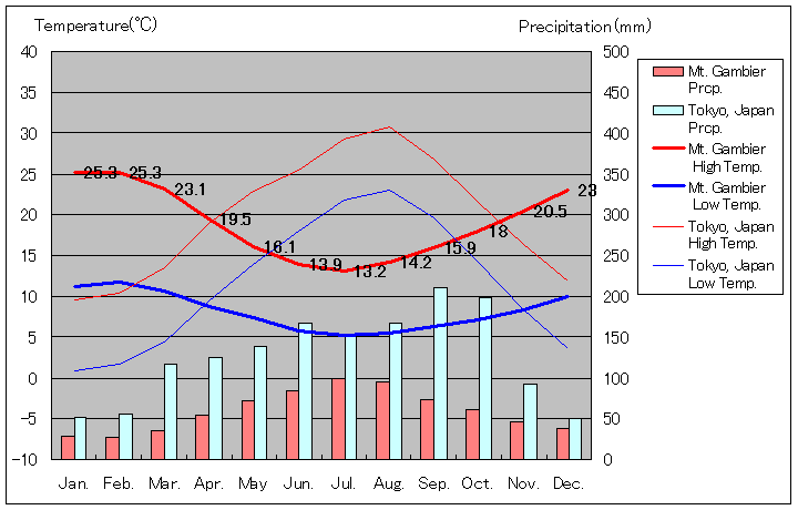
Mount Gambier, South Australia state Temperature & Precipitation Monthly Averages
| Month | Jan | Feb | Mar | Apr | May | Jun | Jul | Aug | Sep | Oct | Nov | Dec |
| Average High Temperature (°C) | 25.1 | 25.1 | 23 | 19.3 | 16 | 13.8 | 13.1 | 14 | 15.8 | 17.8 | 20.1 | 22.7 |
| Average Low Temperature (°C) | 11 | 11.6 | 10.4 | 8.6 | 7.3 | 5.7 | 5.1 | 5.4 | 6.2 | 7.1 | 8.2 | 9.8 |
| Average Precipitation (mm) | 26.2 | 25.3 | 35.3 | 56 | 72.6 | 81.9 | 98.9 | 93.6 | 72.7 | 62.8 | 46.6 | 37.4 |
| Rainy Days | 8.5 | 7.8 | 10.9 | 14.3 | 18.1 | 19.2 | 21.4 | 21.1 | 19 | 17.2 | 13.7 | 11.8 |
Mount Gambier Temperature and Precipitation Graph

Australia Map(Google Map)
Now, Map data loading .....
(If the map is not displayed, There is a possibility to be able to display by permitting JavaScript.)
To the top (Mount Gambier Temperature)
 (Japanese)
Copyright © 1997-2023 ZenTech. All Rights Reserved.
